.jpg) |
| Model of Tokyo Bay (Source: Michael S. Sherry, The Rise of American Air Power (New Haven and London: Yale University Press, 1989) |
The desire to represent real-time data seems quite contemporary, but in fact this practice was borne out of World War II-era architecture and design culture. One characteristic of this practice was the impulse to dramatize physical and environmental data. An image from Michael Sherry’s The Rise of American Air Power (1989) is a useful starting point to demonstrate how this is the case. Here, we see a model of a waterfront and cityscape bordering a flat expanse of water. This flat, "watery" surface extends outward and ends abruptly, revealing a tangle of plywood scaffolding supporting the model. Booms and stage lights overhead suggest that we are looking at a soundstage. It is, in a sense, for this image shows a film crew taking overhead footage of a scale model of Tokyo Bay. But this is done for an entirely different purpose. As Sherry indicates in the image caption, “The Army Air Forces adopted the techniques of Hollywood to simulate reality for crews – one of many wartime efforts to simulate conditions in Japan.” The Tokyo Bay model was “used in the production of training films designed to brief aircrews slated to attack Japanese targets.”[1]
Such combinations of design, theatricality, and war calls immediately to mind the work of the American design polymath Norman Bel Geddes (1893-1958). The 30s were particularly fruitful for Bel Geddes. 1932 saw the publication of Horizons, his well-regarded treatise on the role of industrial design and architecture in the future that featured images and drawings of Bel Geddes's streamlined designs. And later, he designed and directed the "City of the Future" advertisement campaign for Shell Oil from 1936-37, which would eventually become the massively popular Futurama exhibit at the 1939 New York World's Fair. Though Bel Geddes would not have as many high profile projects during the 1940s, his offices were still busy producing a lot of work for the both private and government clients. Starting in 1942, the editors at Life magazine hired Bel Geddes to produce objects at a different scale than he was accustomed to. Most of his wartime design effort consisted of various models and dioramas depicting everything from cloud patterns to the construction of Egyptian pyramids. Yet his models of American combat operations brought Bel Geddes a different kind of recognition. Published frequently in the pages of Life from 1942 to 1945, Bel Geddes' models were essentially highly-detailed terrain dioramas that brought a antiseptic, highly-stylized and design-conscious version of the war to American readers.
 |
| "Coral Sea: Norman Bel Geddes' re-enact naval battle" Life (May 25, 1942) (Source) |
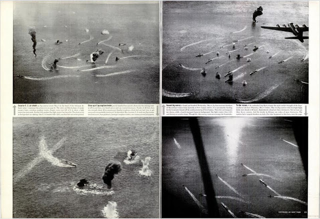
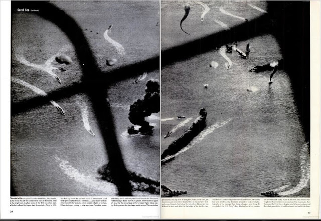
Unlike other images and instances of war reportage — such as Margaret Bourke-White's photographs, Ernie Pyle's installments for Scripps Howard, and Bill Mauldin's cartoons — Bel Geddes' models for Life were essentially didactic in nature. The very first installment, with the descriptive title "Coral Sea: Norman Bel Geddes' models re-enact naval battle," was published on May 25, 1942, only weeks after the actual battle took place. It is, in essence, a spread devoted to six photographs of what must have been a massive model. In each of these, tiny ships maneuver in and out of gunfire, leaving plasticine wakes in the sculpted waters. Pieces of cotton fabric are rendered into flak bursts or into exhaust fumes of aircraft falling into the Pacific Ocean. All of the images — taken by Bel Geddes' employees — are supposed to depict the surprise attack on the Japanese fleet in the Coral Sea. The vantage point is therefore almost always that of a bombardier's sitting in the glazed nose of an Army Air Force or Navy aircraft. And in some instances, great care is taken to construct the aircraft windows and framing. With this technique. Bel Geddes provided the reader with an approximated, yet simulated depiction of battle in real-time. The caption to the leading image thus reads, "Jap convoy flees (top) when Jap task force of warships (bottom) is attacked by bombers on Monday, May 4. Scene a few minutes later is on the next page."
 |
| Details of models, from "Coral Sea: Norman Bel Geddes' re-enact naval battle" Life (May 25, 1942) (Source) |
Although great care is taken in identifying the various ships and airplanes used in the battle, the scene remains geographically ambiguous. A more traditional mercator projection of the area locates the exact "position" of each image. And yet there is still some guesswork involved. The caption to the image of a model of a B-17 Flying Fortress "surprising" a Japanese Navy convoy tells us that the enemy ships were "presumably heading for the Louisiade Islands off the southeastern tip of New Guinea." The article explains that Bel Geddes produced these models because "There has never been a clear and complete photograph of a naval battle." This is why the scale of the models is so small. Great effort is taken to portray as much as possible, to fill each image with as much information as possible about the conflict. This includes environmental details such as the exact position of a flak burst in relation to the surface of the water, and the water itself. Indeed, all images show a maniacal fascination with how ocean waves ripple and break, an overdetermined effort to demonstrate that this battle is occurring in the high seas.
 |
| "Geddes Map Shows Where Rommel Hit U.S. Army's Flank," Life (March 1, 1943) (Source) |
Other models place a premium on geographical information, oftentimes resorting to more standard cartographical techniques as part of the visual strategy. For the March 1, 1943 issue of Life, Bel Geddes produced a detailed model of the North African coast showing how Field Marshall Erwin Rommel's forces were able to break through the Allied salient. Here, dotted and dashed lines, as well as directional arrows show the relative locations of American, British, and German forces. Islands and cities are labeled, and a north arrow, drawn as if on the surface of the Mediterranean Sea, figures prominently. These are all clues that this is much more than a map. Although the article is titled "Geddes Map Shows Where Rommel Hit U.S. Army's Flank," the text identifies the map as a "relief model of the North African battlefield."
 |
| "Allies Advance From East and South to Close a Pincer on Jap Base at Rabaul," Life (October 4, 1943) (Source) |
 |
| From "How The Russians Took Orel: Models by Norman Bel Geddes Show Red Tactics in Winning Their First Big Summer Victories," Life (August 16, 1943) (Source) |
 |
| From "Sicily Invasion Goes Well," Life (July 26, 1943) (Source) |
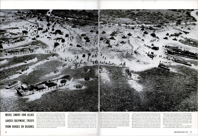
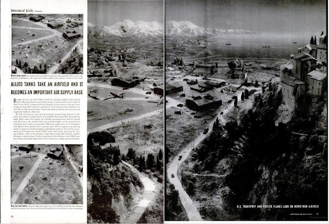
Bel Geddes' built his models at different scales in order to present varying degrees of combat veracity. His model for "Sicily Invasion Goes Well" (July 26, 1943) is perhaps his most spectacular. Here, Bel Geddes follows the same general presentation strategy as the Coral Sea model, the only difference being that most of the scenes and models are larger-scaled. Battleships, amphibious assault vehicles, and even landing craft appear almost toy-like. Yet trees, rocks, grass are all rendered meticulously, giving this "fake" scene an attenuated reality. It is this overwhelming stasis, this heightened artifice are what give the model a dramatic sense of the island's terrain and environment. The image of the very last model gives us the best sense of this. Titled "Allied Tanks Take and Airfield and It Becomes an Important Air Supply Base," this is the most action-packed of all Bel Geddes' models.
 |
| From "Sicily Invasion Goes Well," Life (July 26, 1943) (Source) |
A giant monastery dominates the foreground as models of C-47 transports land on the newly-taken airfield. In the background, the chaos and devastation of war seems to have momentarily ended. Except for a large bloom of cloudy smoke in the faraway mountains, there are no plumes to show where artillery bombs and shells have just exploded. Instead, there are just trees and people moving about the various damaged houses and structures. And far off, American ships continue towards the Sicilian coast unopposed. This is much more than a model depicting business-as-usual. This is a map that has come to life.

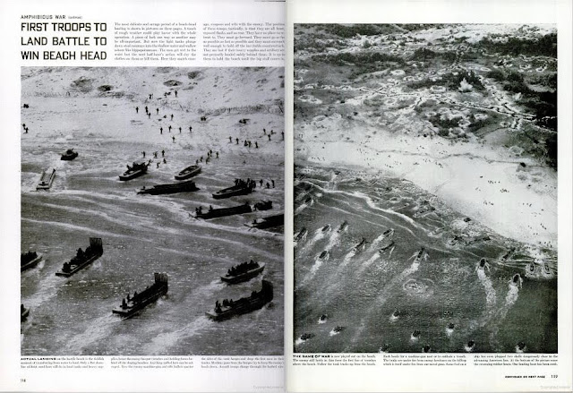 |
| Top and bottom, models from "Amphibious War: Geddes Models Explain Land-&-Sea Attack," Life (November 16, 1942) (Source) |
In some instances, there were no degrees of veracity, but only wholly fictionalized accounts of war. For "Amphibious War: Geddes Models Explain Land-&-Sea Attack" (November 16, 1942), Bel Geddes created a series of scenes to illustrate how an coordinated air, land, and sea attack would commence on a fictional Pacific island. The title image features a superimposed photograph of two Douglas TBD Devastator torpedo bombers "attacking" a model airfield sited high on a bluff overlooking the Pacific. The rest of the images are very upfront in their didacticism: they are supposed to illustrate, via aerial views, the various stages of an amphibious assault. All aspects, from naval bombardment to the very first landings via LST and LCPL; from tank warfare to trench digging — these become part of an orchestrated effort to teach the public the subtle art of tactics. It is Clausewitz for the masses. The image caption to the model of the first landing sums it up best: "The game of war is now played out on the beach."
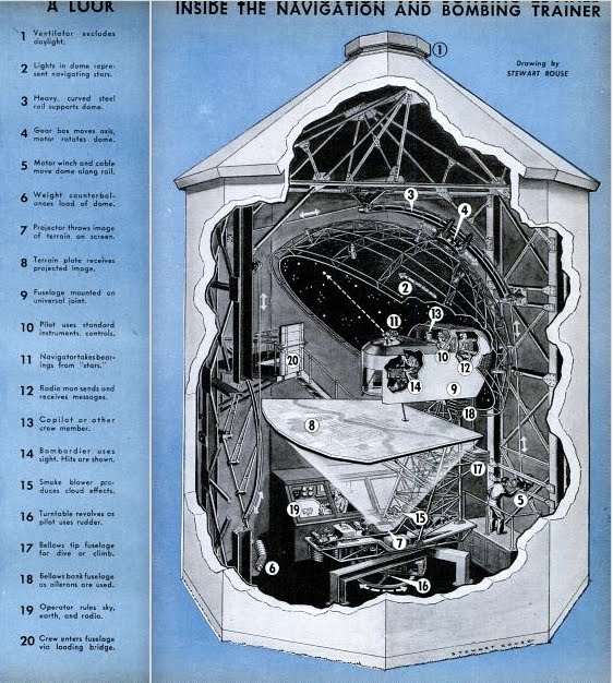 |
| Celestial navigation trainer, from Robert L. Scott, Jr., "Bombing Tokyo From a Silo" Popular Science, Vol. 144. No. 4 (Apr., 1944) (Source) |
The statement is much more than just a tongue-in-cheek description of how the models only approximate war. It also alludes to how the military used models like the Tokyo Bay device and Bel Geddes' "scenes" for more immediate ends. In an article for the April 1944 issue of Popular Science, Flying Tiger veteran (and author of God Is My Co-Pilot) Robert L. Scott wrote of his experiences using a Link Celestial Navigation Trainer. Housed inside a silo-like building, celestial navigation trainers featured the nose-section of a bomber, complete with instrumentation for a pilot, co-pilot, radio operator, and most importantly, a bombardier/navigator. Covered by a hemispheric canopy with constellations painted on the inside surface depicting constellations, these trainers were designed with the sole purpose of instructing aircrews in the intricacies of using sextants and other navigational aids aboard aircraft. And like the Tokyo Bay model that helped introduce this post, celestial navigation trainers also relied on a more "cinematic" form of modeling. Consider Scott's description of how crews use the nose-section inside the trainer. Scott recounts, "the screen, or terrain plate, which received the projected images of any part of the earth's surface. I heard that those scenes appeared as if actually viewed from an airplane at 10,000 ft, but others could be projected with any altitude desired. Images of clouds in any given density could be thrown upon the same screen. Drift from anticipated cross winds, or resultants of head winds or tail winds, could also be introduced."[2] Could celestial navigation be anything more than a multimedia experience?
This is not entirely off the mark. Celestial navigation trainers were a fixture at the Army Air Force School of Advanced Tactics, or AAFSAT, in Orlando, Florida. They were part of a intensified effort to deploy new technologies to organize and train the Army Air Forces in strategy and tactics. As stated in a 1944 report detailing the AAFSAT's achievements,
It is desirable that an army or air force be so organized that information necessary for tactical development be immediately available, that new tactics be rapidly and thoroughly worked out, and that the results be quickly disseminated. However, tactics is such an integral part of every activity in the AAF that the problem cuts across all conventional organizational barriers and constantly defies efforts to isolate the function and assign it to a single authority or organization. There are tactical aspects to training. There are training aspects to every tactic. There are nearly always some materiel problems presented by a newly conceived tactic.[3]One kind of tactical problem that necessitated its own brand of information organization and presentation was the coordinated air, land, and sea attack. A new kind of trainer was needed, and in 1943, AAFSAT enlisted Norman Bel Geddes to assist in this endeavor.
In February of that year, Bel Geddes contracted with the AAFSAT to develop the "Synthetic Training Device #1." It was to be part of a multimedia environment using maps, sound recordings, and information displays featuring Translux rear-projection technologies and scale models of planes, tanks, and terrains. The trainer was supposed to be the most advanced tactical simulation center ever devised for combat training. It not only was supposed to provide and coordinate an extensive informational environment giving status updates on hundreds of combat operations, but it was also supposed to rely on the physicality of models as part of its information design. Everything was supposed to be housed in a giant operations center. As described in an issue of the Orlando Morning Sentinel, the center was to include "facsimile models of every tank, airplane and naval vessel made in the world, or own, our Allies, and the enemy. There are dozens of sand stables which present almost every type of terrain a plane will move over in every combat zone. There are hundreds of fine scale maps with accurate battle lines."[4] Bel Geddes was also in the process of developing an "animated tactical board" for the project. As described in the Orlando paper,
The board will be 60 feet square and by comparison will cover about 150 square miles in scale. On it will be two complete armies, with cities, local terrain, communication and transportation lines in actual scale. Above it will be the operating air forces of the enemy and the Allies .... As 216 electric motors operate it, the armies and air forces will go into actual combat. Bombs will drop, armies will clash, artillery will roar, planes will shoot down one another ... Inside rooms approximately 200 students of the air and ground forces will work out a simulated battle taken more than likely from a batttle that is in actual combat at the moment. By intricate electrical boards, orders will be given. It is these orders which will determine the outcome of the battle.[5]And though the design and construction informational displays presented Bel Geddes with what was perhaps the most difficult aspect of the project, most of his discussions with Army Air Force officials concerned the large terrain model that would be at the center of the operations center.
These discussions not only discussed what the terrain model should depict, but how. As for the what, Bel Geddes agreed to build a 1:1200 relief map of Northern Florida that could be altered to represent different geographical areas. The inclusion of model roads, railroads, power transmission lines was also important, as these would be present in any kind of environment that would be "attacked" in the simulator. The objective of each simulation would be to "take" Jacksonville, which could also altered to depict any urban area anywhere. And at a March 31, 1943 meeting in New York, Bel Geddes, his designers, and AAFSAT agreed on the how of the terrain map. The minutes from that meeting reveal how "The culture of the map, should, in the battle zone, represent as closely as possible the battle scenes and encampments in the photographs of terrain of Guadalcanal (Time and Life Pictures of the landing)."[6] It is a comment that is as illuminating as it is revelatory — not only did AAFSAT faculty want Bel Geddes to duplicate some of the terrain models that he was already constructing for Life, but they are referring to a specific model of his: the model of Guadalcanal he produced for a series of articles called "U.S. Fights for the Solomons" (November 9, 1942).
 |
| Bel Geddes' model of Guadalcanal, from "U.S. Fights for the Solomons," Life (November 9, 1942) (Source) |
Although Bel Geddes only created diagrams and a rough model of "Synthetic Training Device #1," the demand for his relief models found other avenues. For MoMA's popular Airways to Peace exhibit from 1943, for example, he created a terrain model depicting a swath of land extending from the English Channel to Switzerland.[7] MoMA also devoted a show to his "War Maneuver Models" in 1944. Bel Geddes would continue to produce such models up until 1946, eventually using this technique in one of his most architectural projects.

 |
| Top and bottom, images from "Future Toledo: Scale Model Gives Citizens A Prophetic Look At The Wonderful City They Could Have in 50 Years," Life (September 17, 1945) (Source) |
In February 1945, newspaper empresario Paul Block hired Bel Geddes to build a gigantic scale model of Toledo, Ohio showing how the city would look in the future. A feature in Life shows an aerial photograph of "Future Toledo" with gray shading depicting areas to be cleared and rebuilt. It was, in a sense, Bel Geddes' own Ville Radieuse, a vision of future urbanism that required substantial interventions in order to be realized. But the actual solutions that Bel Geddes presented rang familiar. With multi-tiered expressways and roundabouts, elevated sidewalks, and extensive airport planning, "Future Toledo" was in many ways a rehashing of Bel Geddes' previous work for Shell and for the Futurama exhibition. Then again, this project was something of a completely different order. As the article points out,
One all-important thing the model does not show — how to bring it all about. But with so many of its residents seeing and understanding the benefits of city revision, Toledo is getting a better-than-average start on all the myriad legal and financial troubles which must be cleared away to make the model a reality.[8]It is a poignant statement, to be sure. The different kinds of visualization and modeling techniques that were a vital part of the war effort are deployed here for a peacetime role. "Future Toledo" is much more than a revisiting of Futurama. It is a terrain model very much in the same vein as those created for Life. And like the proposed "Synthetic Training Device #1," Bel Geddes' last urban vision attempts to duplicate a massive organizational and representational effort. Here, however, the emphasis on tactical and combat simulation is replaced with an emphasis of civic engagement. The reliance on terrain modeling remains.
_______________________
Notes
[1] Michael Sherry, The Rise of American Air Power: The Creation of Armageddon (New Haven, Yale, 1989), n.p.
[2] Robert L. Scott, Jr., "Bombing From a Silo," Popular Science, Vol. 144. No. 4 (Apr., 1944), p. 58.
[3] Assistant Chief of Air Staff, Intelligence Historical Division, The Development of Tactical Doctrines at AAFSAT and AAFTAC, Army Air Force Historical Studies: No. 13 (Jul., 1944) p. 3, USAF Historical Division, Archives Branch, Maxwell Air Force Base, Alabama.
[4] John Forney Ruby, "Air Forces School Works Out Battle Tactics Here for Aerial Combat Zones" Orlando Morning Sentinel (12 May 1943), Norman Bel Geddes Theater and Industrial Design Papers 1873-1964, Job 487, Box 34, Job Diary — Meeting Minutes, Correspondence, Feb.-Dec. 1943, Harry Ransom Center for the Humanities, University of Texas at Austin.
[5] Ibid.
[6] Minutes of Meeting between Norman Bel Geddes, AAFSAT Faculty, 31 March 1943, Norman Bel Geddes Theater and Industrial Design Papers 1873-1964, Job 487, Box 34, Job Diary — Meeting Minutes, Correspondence, Feb.-Dec. 1943, Harry Ransom Center for the Humanities, University of Texas at Austin.
[7] MoMA to Norman Bel Geddes, 13 July 1943, REG, Exh. # 236. The Museum of Modern Art Archives, New York.
[8] "Future Toledo: Scale Model Gives Citizens A Prophetic Look At The Wonderful City They Could Have in 50 Years," Life (September 17, 1945), p. 87.
